
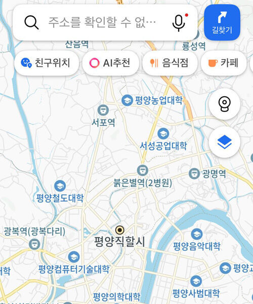
▲ Map of Pyongyang on KakaoMap
The detailed display of North Korean regions on KakaoMap has become a hot topic online.
According to the information and communications technology (ICT) industry today (June 22), numerous posts have recently appeared on online communities noting that North Korean regions are visible on KakaoMap.
When users move the map's focus to the Pyongyang area within the KakaoMap app, they can identify various facilities, including Kim Il-sung University, Taedonggang Station, Pyongyang University of Education, Pyongyang University of Computer Technology, and Pyongchon Station.
Kakao explained that it has been providing maps of North Korean regions, including general and satellite views, since before 2014.
The company added that it displays North Korean regions on KakaoMap by utilizing various data sources, such as maps from the National Geographic Information Institute.
In contrast, Naver Map displays North Korean regions in a more simplified manner compared to KakaoMap.
When searching for Pyongyang in the Naver Map app, facilities such as universities or hospitals are not shown; users can only view geographical features like rivers and bridges.
The difference lies in the fact that, unlike KakaoMap, Naver Map integrates OpenStreetMap.
OpenStreetMap is a non-profit online mapping project that began in the United Kingdom in 2004, allowing anyone to freely participate in creating and utilizing maps of the world.
Similar to the online encyclopedia Wikipedia, anyone can edit or add map data, and individuals, companies, and countries can use the map data for free.
However, it is impossible to view maps of North Korean regions on both Naver Map and KakaoMap by typing related search terms into the search bar.
Because searches for locations related to North Korea are restricted, users must manually navigate the map to North Korean regions to view them.
(Photo: KakaoMap screenshot, Yonhap News)
※ Please note: This article was translated by AI and may contain errors.